- Support portal
- Evaluation Kits and partner products
u-blox Support
- Product documentation
Documentation
- Investor relations
Investor relations
Insights
|
17 Nov 2022
Subsurface mapping undergoes a paradigm shift by leveraging high-precision GPS.

Screening Eagle combines ground-penetrating radar with u-blox’s GNSS augmentation service to map the subsurface in a radically easy-to-use way, producing a meaningful 3D map of the underground in real time.
What do you think of when you hear the term paradigm shift? What drives us to make fundamental changes in how we see the world, do things, or in what we believe? The term paradigm shift is reserved for such disruptions. It occurs when new and emerging technologies cause a radical change in our approach to develop processes, products, or services. This article describes the type of ‘aha moment’ that results in a game-changer for subsurface mapping.
Ground-penetrating radar (GPR) is a geophysical location technology that has been used for decades in various geophysical applications, from utilities to archaeology, to detect what lies below the ground in a minimally invasive way. GPR's greatest advantage is its capacity to locate objects without breaking the surface. GPR surveys virtually and cost-effectively through a range of applications, including utility mapping, subsurface mapping, and excavation projects.
Unfortunately, three pain points have remained a constant with traditional methods:
These limitations drag and hassle subsurface mapping projects, extending lag times between the first on-site scans and when the actual underground project work begins.
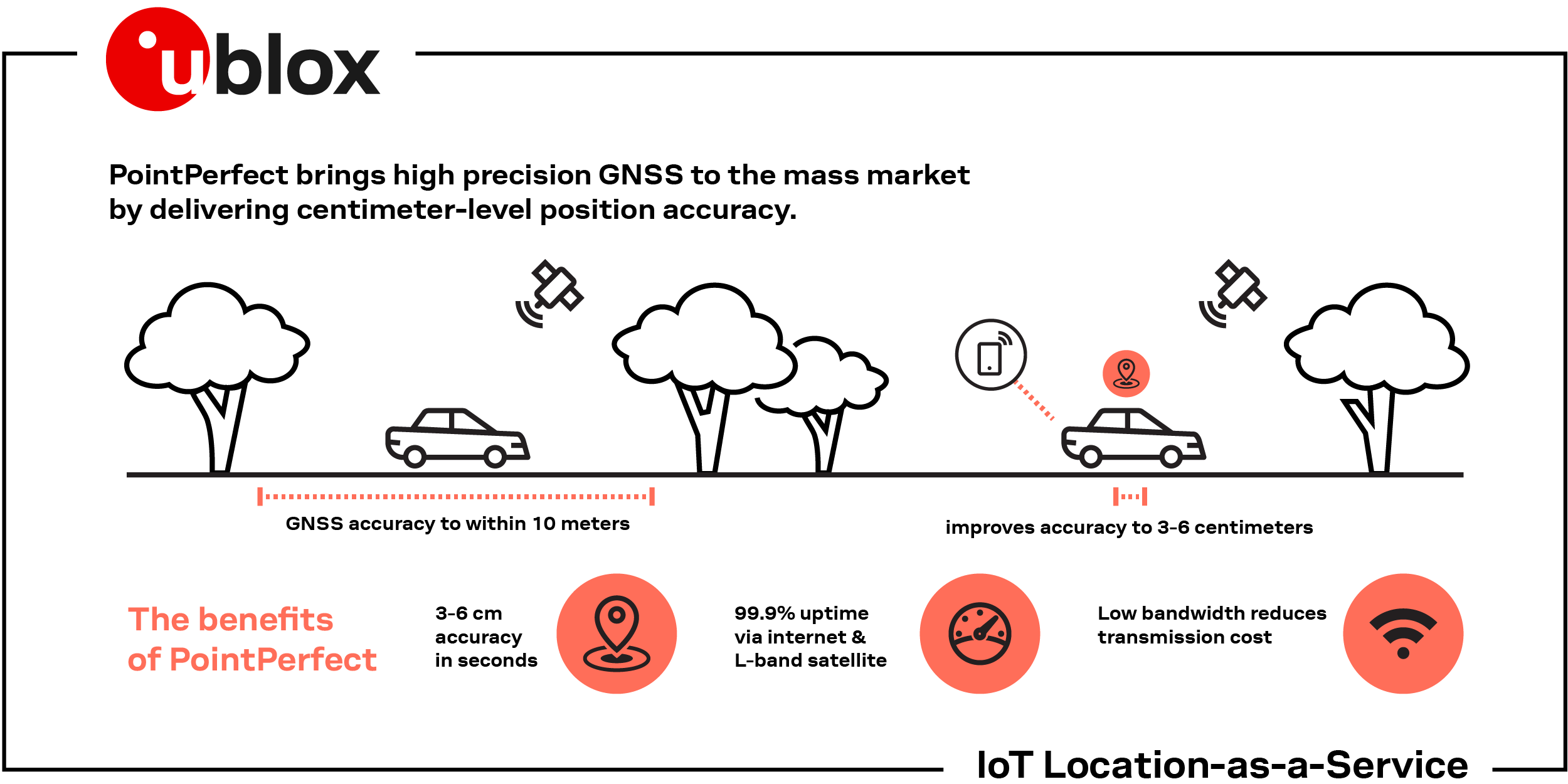
Until now, determining an accurate position for subsurface mapping required survey grade global positioning satellite (GPS) receivers and real-time kinematic positioning (RTK) systems. This solution, however, involves an expensive combination of hardware and services that includes capable receivers (costing between thousands and tens of thousands of dollars), RTK software (costing hundreds more) and additional costs such as peripheral hardware (tripods, poles, or rover rods.)
Field surveys can be time-consuming, taking days or even weeks, depending on the size and scope of the project or the complexities of the land. When expediting a site survey, practical considerations such as the RTK system’s reliability, coverage, and availability become mission critical.
Answering the pain points of the traditional approach requires combining the most advanced GPR technology with the latest in high-precision global navigation satellite system (GNSS) technology.
Fortunately, today we can answer the demand for accurate positioning through solutions that stand apart from the traditional ones. We can build high-precision products by combining GNSS receivers and available augmentation services that are highly accurate and globally available. These products, employing a technology known as PPP-RTK, from the fusion of precise point position and real-time kinematics, can deliver precise solutions virtually everywhere without the need for time-consuming and costly field surveying activities. These solutions achieve performance on the range of sub 10cm accuracy in a relatively short time, often within few seconds, thus allowing the operators to focus on targeting underground mapping. Furthermore, delivery flexibility and pricing models make the operational costs predictable and easy to factor within the overall business cost structure.
These significant advances have moved high-precision GPS solutions from expensive, customized, and time consuming, to a new mass market era. Innovators are changing underground surveying radically by enabling geophysical location applications to take advantage of value-driven, high-precision GPS solutions.
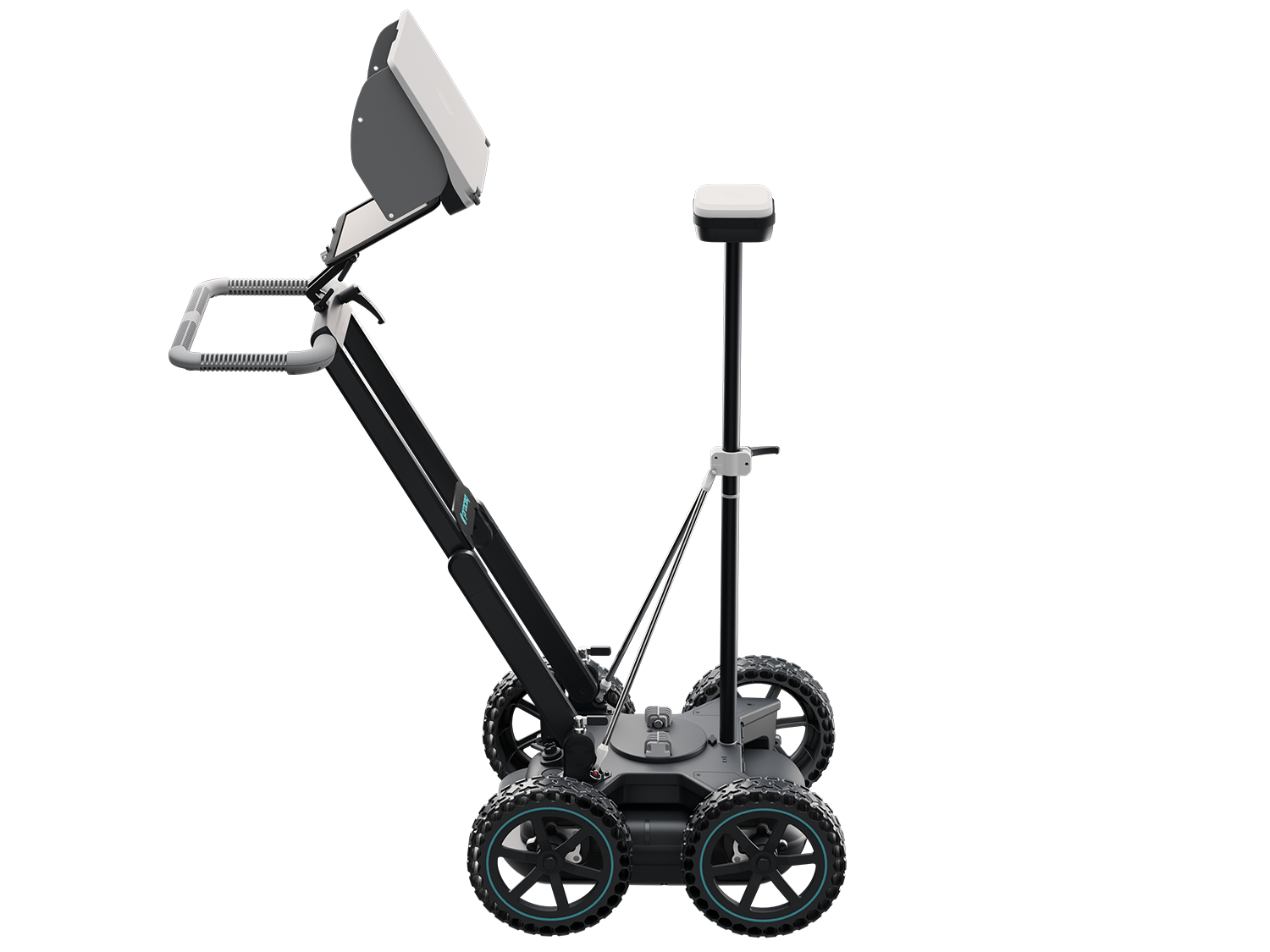
Considering the advantages that this paradigm shift brings, customers such as Screening Eagle have combined geophysical location technology with u-blox’s PointPerfect GNSS augmentation service. The Screening Eagle GS8000, an underground utility mapping system that combines the latest advances in GPR with state-of-the-art GNSS, not only locates underground objects but it also digitizes scanned features and linework on a 3D map and output to CAD/GIS directly from the field. As a result, GS8000 is as much a surveying tool as it is a GPR.
“PointPerfect brought the possibility to offer GS8000 customers a next level user experience. With just one click, users enjoy survey-grade accuracy out of the box across Europe and USA, producing geolocated 3D imagery of the underground – literally as they walk. This reduces pre- and post-scanning time and hassle to virtually zero; the guesswork is also largely removed from the equation. Three birds, one stone.”
-- Gorka Santamaria, Sr Product Manager, Screening Eagle
PointPerfect benefits:
There are various ways engineers can test and evaluate PointPerfect. See the different ways to evaluate PointPerfect and F9 and see if it's the right for your application.
Frictionless for business
An aspect that differentiates our solution from others is its delivery method. Thingstream IoT service is the enterprise-grade cloud platform that utilizes auto-scaling technology to deliver all u-blox services. The intuitive interface provides a self-serve environment where users may manage IoT device fleets, billing, monitor events, and have complete API control of functionality with absolute autonomy. So far, it has proven to support billions of messages. In addition to a traditional subscription-based approach, we offer flexible pay-as-you-go service plans to address various customers, use cases, and applications. Thingstream enables a frictionless business experience as it eliminates complexities – its users engage more efficiently and reduce time-to-market considerably.
Reduced transmission costs with the SPARTN data format
Modern positioning systems require a combination of low bandwidth, high accuracy, availability, reliability, and integrity of communication between service providers and end users. The SPARTN format is an industry-driven messaging standard designed to meet these requirements. SPARTN combines the advantages of state representation with modernized communication protocol fundamentals, resulting in a bandwidth-optimized solution that reduces transmitting costs for end users.
Traditional solutions require a separate bi-directional stream of communication for each endpoint, resulting in high bandwidth and data consumption that brings scalability challenges. PointPerfect uses a single outbound broadcast stream for all endpoints, providing scaling efficiencies that enable mass-market use cases.
Being an open protocol, SPARTN enables any interested party in the GNSS industry to design products or services based on it without further licenses or fees of any type.
Highly efficient message delivery via MQTT
The highly reliable, lightweight MQTT protocol is vastly more efficient than HTTP when transmitting many messages on a single connection. Lower overhead and simplified messaging transport mean less data and lower transmission costs. MQTT protocol is scalable: broadcasting a message to a million devices is as easy as to send it to just one. Because MQTT clients are embedded in many connectivity products, there is no need to integrate a dedicated or proprietary client, which is a common requirement when the NTRIP protocol is used to stream GNSS correction data.
By combining advanced geophysical subsurface location methods with a value-driven GNSS augmentation service, customers like Screening Eagle are changing subsurface mapping. In a radically easy-to-use way, now it is possible to produce a meaningful 3D map of the underground in real time. For that, survey-grade geopositioning was paramount.
Pain points solved:
“We can proudly say that the GS8000 system has changed the way the subsurface is mapped, bridging the gap between geophysical and geospatial worlds. Our collaboration with u-blox has been instrumental in achieving this – I cannot wait to see where these developments lead us in the future.”
-- Gorka Santamaria, Sr Product Manager, Screening Eagle
Learn more about how PointPerfect GNSS augmentation service can enable a radical change in your high-precision GNSS mass market applications. Contact us for more information.
1 Horizontal accuracy: Typically, 3-6 cm with a compatible receiver. All accuracy results are based on:
a) error-free GNSS observation data
b) receiving complete and uninterrupted correction data
c) ambiguity-fixed position results
Franco de Lorenzo
Principal Product Owner, u-blox Services